
Bills Thrill rapid on Richland Creek in low water
In Arkansas, there are times of drought and times of heavy rains which create high flows in Ozark and Ouachita mountain streams. In a normal year, most of this high water will happen in mid to late March and most of April, and starts to wind down by mid May. Usually by June stream flows in all but the largest trunk streams will be down to a very small flow. However this year, all of that logic was thrown out the door as Arkansas had quite a late spring with freezing temperatures still happening into late April. As May rolled in strong storms developed several times during the month, however by the heaviest amount of rainfall came in a period over 2 days, 05/30/13 and 06/01/13.
The heaviest amount of rain fell in the southwest part of the state, and this brought up all the main streams. There was locally heavy flooding and some fatalities occurred during the flooding. I tend to gauge the stream flow in Arkansas by reviewing the levels of what I determine are critical trunk streams:
- The Cossatot River in the southwestern corner of the state
- The upper end of the Buffalo National River near Ponca Arkansas
- Richland Creek in the center of the Richland Wilderness
I use the USGS gauges, which are online at this location. You can get an excellent feeling for how much rain has fallen by looking at the stream flow increases. If you look at the series of images from the gauge on the Cossatot, you can see that the stream rose to around 30,000 CFS (Cubic Feet per Second of flow) in around 2 hours. This is classic flash flooding and is a very dangerous time to be out driving around on local road. What’s also telling is just how fast the Cossatot fell back to a “normal” level. By looking at the charts, you can see that really before daylight, the Cossatot had already dropped back down to a much lower level. What is even more interesting, is that in the 2nd heavy rainfall on the night of 06/01/13, the Cossatot rose back up to close to 20,000 CFS again in less that 2 hours.
-
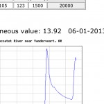
- Two day view of the level of the Cossatot River hitting 30,000 CFS
-
- Two day view of the Cossatot River No 1
The first graph shows the two peak levels, of 30K and 20K in a total overall time frame of less than 24 hours. The 2nd graph shows the final peak reading on 06/01/13 where the river recorded over 20K CFS. I have seen a video taken by Max Wellhouse way back in the late 1990’s of the Cossatot at 10,000 CFS, so I can only imagine it at 30,000. The 6 falls of the Cossatot would be a site to behold if you could even get down to shoot around them. I am assuming that the water would be pretty maxed out in the narrow canyon that is created around the 6 falls and any viewing would have to be done from above the level of the falls on the surrounding bluffs. So what about the northwestern part of Arkansas, well not quite as much rain fell, but Richland creek most definitely saw the same double peaking like the Cossatot.
Anyone who know me or my work, knows I am a bit partial to Richland Creek. Hands down it provides some of the best photographic studies in Arkansas. This is true in winter, spring, summer and if you are lucky fall. Catching Richland with a good flow in the fall is very prone to luck. Richland is enjoyed by a huge cross section of recreation seekers in Arkansas and other local states. This includes:
- Kayakers
- Hikers/Backpackers
- Photographers
- Hunters
- Fishermen
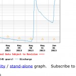
There is a great primitive campground about 1/2 way of Richland’s length where forest road 1205 crosses the creek. Since 1974 I have hiking, photographing, or kayaking on Richland and know it very well. By gauging Richland creek you can get a great feel for how high the smaller tighter streams are running, like Falling Water Creek, Bobtail Creek, Big Devils and Long Devils creeks. All of these smaller creeks have individual features that make them appealing. On the 30th of May, Richland rose up from around 150 CFS to over 9000 CFS in less than 3 hours. This much water on Richland is easily what I would call a flash flood, and would most definitely cover the bridge at FS 1205. This amount of water may also start to flood into the lower level of the campground. What also has to be remembered is that at the campground, Falling Water Creek also comes into Richland. Falling Water Creek would be the largest tributary to Richland, with Bobtail creek being the 2nd. If there was 9000 CFS at the Richland gauge, easily 1/3 of it was coming in from Falling Water Creek. In the images below you can see just how fast Richland rose up.
-
- Richland View gauge view no 1
-

- Richland View gauge view no 2
-

- Richland gauge view no 3
In the first shot, you can see the same double peaking that occurred in the southwestern portion of Arkansas. Richland’s rise was a bit closer together, in that the peaks are between the 05/31 and 06/01. The first peak was close to 9000 CFS and the 2nd one came in around 2140 CFS. I have kayaked Richland one time at a approximate level of 4200 CFS in a great November run. I can safely say that I would not want to be attempting to run the creek any higher.
The downside to this is the damage the high water has on the creek features. Rocks will all now show what I like to call a bathtub ring effect since this much water will scrub off a lot of the lichens that are growing them and give them such great character. Also any tree or shrub that might have been growing along the bank or in the creek will be totally denuded by the force of the water. This will all clear up with time, however for a while the stream will have a very different look. With Richland you can also assume that some of the rapids have changed a bit as 9000 CFS is plenty of water to move over big rocks. Also some trees may have fallen into the creek and will have to take the normal course of moving on downstream with the next high water.
When Richland gets to this level it’s time to hunt out the smaller, tighter streams that most times don’t have the dramatic flows. Streams like Bear Creek near Ft. Douglas, or Graves creek come to mind as both of these creeks have very tight stream beds. Richland is tricky to cross at any level over 450CFS and I personally will not attempt a crossing at any level higher than 400 CFS now. You have to remember that to get over to Big and Long Devil’s creeks and Twin Falls requires crossing Richland in the area of the Big Bend. In past years this was always an easy crossing as there was a large gravel bar that extended out from the mouth of Big Devil’s creek. In the past few years, this is not true and a hiker/photographer has to now make the crossing upstream from here in the rapid immediately above the mouth or in the rapid downstream. I tend to make the crossing on the part of the creek right before the downstream rapid as there are less hazards to contend with.

Normal flow of water at Twin Falls of Big and Long Devil’s creeks
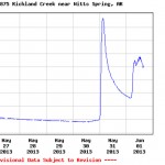
What is so amazing is that now only 11 day’s out from the rain, Richland is back to 31 CFS, a level that is not really that photo worthy. You also have to remember that the Richland gauge level reflects the input from Falling Water Creek, so the level of Richland above Falling Water would be more like 20 CFS. This is enough water to see nice smallish rapids, but not enough to really get the full effect of Richland’s watercourse.
I am sure some other photographers made the trek to the creek, however I spent my time on detailed shoots of Falling Water Creek and Haw Creek Falls, the later of which I will write more about in a later post.


Hi Paul,
Let me begin by saying you have captured Arkansas in a most beautiful manner and have a fantastic collection of imagery. The time and effort that you have poured into your photos and website are truly evident.
I am contacting you because I am travelling on business (non-photographic) to Conway next week (june 2-5) and have a couple of evenings in which I would like to go out and take some photos. I have looked extensively through your website and you give away a lot of your locations but, having never been to Arkansas I’m not sure on travel time, hiking time, etc to any of those locations. Unfortunately, my business schedule has me tied up till about 4:30 each day and I really only have 1 evening in which to go out.
Would you be willing to provide me some more detailed information on a location near Conway so that I can maximize my time while I am there? Arkansas looks like a beautiful state (through your eyes at least) and I would love to take home to Canada a bit of that beauty. Any information you can provide would be greatly appreciated and I would extend the favor in kind should you ever travel up north to the Canadian Rockies. – Sincerely, Graham McKerrell http://www.mckerrellphotography.com