From the BlogSubscribe Now

01/24/24 Sunset over Walton Heights and Pinnacle Valley

A wintertime sunset from Walton Heights in Little Rock featuring Pinnacle Mountain.
Wintertime sunset from Walton Heights in Little Rock overlooking Pinnacle Valley

There are times that the best view of a particular subject is from the air. With the use of a drone, I was able to capture this sunset in several separate images, then combine them into one single image. The dynamic range of the files is limited, so I chose to use exposure bracketing of 5 shots per image, then combining several of the single files to create one image.

The problem with a drone is that you have to be very careful when shooting into the sun as it’s very easy to totally blow out your highlights. This image was taken with a DJI Mavic 2 Pro, which has a 20MP sensor, but the sensor is nowhere near the same quality as a 35mm camera with 20MP or 24mp.

The other problem that can occur is drift, during the series of images. Even in a quick 5 shot bracket the drone can slightly drift and thus the file will not line up perfectly. If this occurs, then it’s best to use load the needed files into Photoshop, as layers, and then use the “align layers” feature. This will usually allow for a close enough alignment so you can proceed with the work.

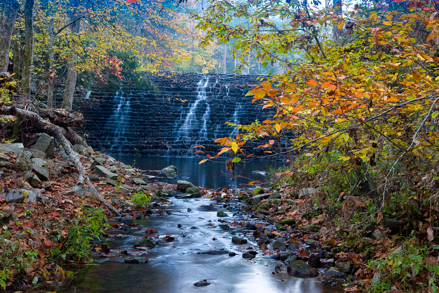
Using a drone often gives a much better perspective overall and I always try to have a drone with me in the woods.

01/14/24 Sunset from Pinnacle Mountain Little Rock, AR

Snowy sunset from Pinnacle Mountain, Little Rock Arkansas
Snowy Sunset from Pinnacle Mountain

This is what might be available the hardy photographers on next Monday or Tuesday as we are going to get another snowy period of 2 days. My days of hiking up Pinnacle on a snowy evening are over however. I wanted to share this image as it brought back some memories.

Arkansas snowfalls are rare in Little Rock, and often times you will get a snowy morning and then as the skies start to clear, you can catch a sunset with the sun shinning on the sun. This particular evening was special as the snow was a wet one and stuck to all the tree branches.

I used a Canon 1ds MKII for this shot and 24-70 lens, which was my go to solution for many years until Nikon came out with the D800. I had more trouble coming down than going up as the snow was very slushy and made the down hike much more dangerous. I was on the part of Pinnacle that I call the nose, which is a solid rock area with no trees. It’s made up of large flat rocks some of which are as long as 12 feet, so if you slip you are going to slide down a long way.

Due to the warning light, I had to shoot quick and all the shots were down hand held. I waited until the last few minutes hoping that the sun would break out from the clouds and I was rewarded with this shot. One of all time favorites of the wintertime at Pinnacle.

A Tale of two creeks Richland and Falling Water–02_21_19 Featured Arkansas Photography

Fall scene featuring Richland and Falling Water Creek at their confluence.

A tale of two Creeks, Falling Water and Richland Creeks, Newton County Arkansas taken November 2018. 

Taken with a Nikon D850 and 24-70 lens.  Image capture in 3 horizontal images @ 24mm.  I used both a CL-PL and ND filter to slow the exposure for the water.

If I had to pick a favorite spot in Arkansas, it would have to be Richland Creek.  Most defiant a love/hate relationship as Richland alone has cost me more in camera gear than any other location I like to photograph.  Just this fall I lost both a Nikon D850 and 24-70 lens upstream from where this shot was taken.  Totally my fault and lucky for me, the creek was much lower so I was able to recover the gear and Nikon USA was able to repair it at a reasonable cost.  But that’s another story. 

Richland Creek is one of the fascinating creeks in Arkansas.  At medium to high water levels it’s a great kayaking stream.  The creek is lined with hardwoods most are 2nd generation growth as the creek was logged back in both the great depression and again in the 60’s-70’s.  Most of the old growth trees are long gone but if you hike far enough upstream where the mules and loggers never reached you can still find some huge white oaks.

The creek also winds through some of the most remote parts of Arkansas, that are still remaining.  Most of the watershed is now a wilderness area.  There is a primitive hiking trail that works it’s way up the left side of the creek (left side facing upstream).  This trail will lead all the way to Twin Falls and Richland Falls, well worth the trip.

For most the season, Richland hold water, but in the fall it’s very rare to find a good flow like the one shown in this image.  Instead the creek is usually barely covering the rocks.  The fall colors are getting tricky to catch also.  In the past the peak display tended to be around the middle of October now the peak seems to be more in the first week of November.  But the display is now hard to catch in full.  Notice in this shot most of the larger trees on the left have dropped their leaves, but the willows and smaller hardwoods lining the creek are still in full color.  However upstream many of the larger trees are still hold leaves.  So you just have to go and see what you have.

To take this shot, I had to wade out into the creek to mid thigh deep.  I found a rock that allowed me to place my tripod and camera safely above the creek.  Still after the disaster I had just 1 week prior, I was a bit shaky on working in the creek.   Still it was just too much not to get out and risk the shot.  There was little to no wind and just as I arrived the deeply overcast sky started to breakup and gave me some nice mixed light.

Due to the high water levels, I was able to catch Falling Water Creek on the left of the shot.  Falling Water Creek runs into Richland at the Richland Campground.  Falling water breaks into several channels near the it’s mouth with Richland and this one is the smallest.  It hardly ever flows unless Richland is running at a high level.  So I was grateful to catch both creeks in the same shot with some of the most amazing fall color I have seen on the creek.


Written by Paul Caldwell for www.photosofarkansas.com.  Please contact the author before using any part of this in a separate publication. 

10/14/16 Fall starting to show it’s colors in Arkansas, but still a lot more needs to happen

This photograph featues the fall vista along Bee Bluff which is on the Buffalo River.  This row of gum trees provides a wonderful display of color the problem is just catching the right light.

This photograph featues the fall vista along Bee Bluff which is on the Buffalo River. This row of gum trees provides a wonderful display of color the problem is just catching the right light.

It’s already the 14th, and in Arkansas the fall colors are really just starting to show.  Arkansas had a very wet August, but extremely dry and hot conditions prevailed during September.  Most of the creeks dried up again and the trees did take a hit for sure.  As of last week, the areas up around the Buffalo river have some nice color beginning to show, but still I am not seeing enough to feel that it will be a uniform color year.   Instead I feel we will have individual species of trees starting to change.  So for now up on the Buffalo, the Sweet Gums and Maples are starting to change, but the oaks and hickory trees have very little to show.

Closer to home around Pulaski County, I visited the Pinnacle Mountain State park this morning.  There were spots of yellow along the road, but also quite a bit of brown.  In my local neighborhood, I am seeing more brown than anything else and we have a very good cross section of trees to look at.  Around the Maumelle River Valley, I am seeing some nice yellows off in the distance so hopefully in about a week the true nature of the color will show.

I still need to travel out to Flatside Pinnacle, as the fall display there can be one of the best in the state, but it always tends to be much later in October.

As of last week, the colors at Sam’s Throne were just starting to show, again mainly in the gums and maples.  Sam’s tends to peak the first weekend in November and has never been a disappointment for me.

Rainfall is still way off for this time of the year even though rainfall totals show Arkansas way ahead for rain.  The Ozarks took a nice rain yesterday, but it only seemed to effect the middle of the Buffalo River.  The Carver gauge showed around 3000 CFS running in the river which is a huge amount of water for this time of year so somewhere nearby the Buffalo watershed received a lot of rain.  Richland is up just a bit to 20 CFS, but that is still not enough to really make the creek attractive for photography.  The upper Buffalo is still very low in the 5 to 10 CFS range.   I have not checked the Cossatot, but I don’t believe it received any rain of measure.

Next week, the heat is back, so it’s still a guess as to if the state will have a good fall display or not.


11/19/15 Red Sky at Night Sailors Delight!!, Wonderful evening shot from the upper Piney Creek Wilderness Arkansas

Piney Creek Arkansas

Sunset from a bluff in the Piney Creeks Wilderness

This is a shot that I like to think, puts all things back into perspective.  For 2015, the Autumn in Arkansas the colors were just terrible.  We also had a lot of rain late in October, which was too late for the streams.  All the streams are running now, but of course they look like they do in winter, just bare trees.  I like to work some of the smaller creeks in Arkansas during fall as the combination of fall colors and running water can be additive.  Arkansas has so many streams, one could never work all of them in a lifetime.  But what we found this year, were mainly cloudy skies, and dry creek beds.  The spring and summer had been so promising.  We had record amounts of rainfall and cool conditions.  But then July, and August.  Basically Arkansas recorded almost no rainfall during these months and it was hot.  Basically what happens, the trees start to go dormant and into protect mode.  If this continues for a long period of time, it will have a negative effect on the fall colors. 

What we basically saw in the fall in most of the spots, were trees turning a dull brown, even in early October.  But even worse, some trees, were staying green much longer so there was no balance in the colors.  I have seen shots from all over Arkansas, and in most of them you are still able to see quite a bit of green trees and most of the trees that have turned are just brown, or dull red.  Gone from the woods this year were the bright yellows, and reds, mainly from the Black Gums, Maples, Black Gums, Hickories and Golden browns from the Oaks. 

I had found a great new spot in the upper Piney Creeks wilderness thanks to Chris Kennedy.  Chris had found this place a week before during the opening of Arkansas Deer season.  I had been here a lot during my kayaking days in Arkansas, but had never taken some time to go look for fall color.  This is a great spots as you are looking due south on one side of Parker Ridge Road and if you cross over and take a short hike, you are looking north.  Either view gives an expansive view of the valley of Big Piney Creek.  If we had been here just one week earlier, the possiblites were endless as it was apparent that the trees in this part of the state did not go into as much stress.

Chris and I drove back to this spot a week later, and most of the color was gone, at least in the trees.  We had a mixed sky with only partial clear patches, but Chris felt it was worth staying around until about 20 minutes after the sun had set.  He had been here before and felt we might get a great play on the afterglow.  He was right, as you can see in this shot, the sun’s angle was just at the right position to really pop the clouds and just painted the sky red.  Chris took this shot with his phone, and it’s a good one even from a phone.  You can see both cameras setup and a good bit of the view from the place were were setup. 

In the spring, this might be another great place to setup, and I hope to come back here for both a milky way shoot and star trails shoot.  It’s not far from the road so working at night will not be a big danger to the photographer. 

But back to my opening, yes this shot did put things back into perspective for me.  I had been chasing color on and off for 30 days and just had not found anything to feature for this year.  In fact this will the first year I have basically no photograph from the fall in Arkansas.  Maybe I am just tired of it, and don’t have the energy anymore as the market I am shooting in has changed dramatically in the past 3 years.  But it was nice to sit on this bluff edge, and think back over the years that I have enjoyed in Arkansas’s outdoors.  We have a beautiful state in many ways. 

11/10/15 Springtime at Haw Creek Falls–A great place to spend a day in Arkansas

Haw Creek Falls, waterfalls in Arkansas

Springtime View of Haw Creek Falls in the Arkansas Ozarks

Taken with a Phase One IQ260 and Arca rm3di tech camera/40mm Rodenstock lens

This is a typical day at Haw Creek falls, and I was again lucky to be there without anyone else to stand around and get in the way during the shoot.  Haw Creek is a lovely smallish creek that runs in the Big Piney Creek, not far from these falls.  The falls are impressive since there is a large ledge that runs all the way across the creek and in higher water conditions the water will start to consume the entire ledge.  I like to catch water about like this, just enough to keep most of the ledge in play but not too much to flood out the rocks below the falls.  To get this shot, I used my Arca rm3di camera which allows movements like a large format camera with my digital camera back.  The shot is actually a composite of 3 images, Left, Center and Right.  The Left and Right segments represent 16mm of shift in those respective directions.  This allows you to create a very high resolution panorama without any of the issues like parallax.  The lens I used was as 40mm Rodenstock HR-W which allows for an excellent field of view when shifted.

You have to be careful when working Haw Creek as there tends to be a lot of wind blowing down the creek.  In most cases, I prefer to take a 1 to 4 second exposure of the water which in most cases will have a lot of wind blur in the trees.  So you have make sure to cover the tree movement with a second series of exposures around 1/125 to 1/250 to stop the wind movement.  It’s a simple process to combine the files later since I am using a tech camera and the movements are very precise.  To allow the longer exposures I used both a Circular Polarizer and a Neutral Density filter.    The polarizer will help with glare on the water and rocks and adds about 1.5 stops of exposure to the shot.  As this was a bright day, I had to use a 1.2x ND filter.  When I was taking the faster exposures for the trees, I left the polarizer on, but took the ND filter off as I no longer needed the extra exposure compensation.

As I already mentioned, Haw Creek Falls, tends to be overrun with people during the peak times of the year.  The best day to go is a Monday as there will not be as many people at the campground and thus less traffic around the falls.  There are some great swimming spots above the falls in the large pool that is created by the ledge.  It’s a great place to head to when you know you have some water running in the creek.  Also the Ozark Highlands Trail runs right by Haw Creek falls, so if you are planning a hike on this part of the trail make sure to stop and take a look.

The falls run year round, but the best times to photograph them are in the early Spring and winter when water levels are more consistent.  In the summer and fall you can sometimes get lucky after a locally heavy rainstorm and catch the falls running.  The fall display here is wonderful if you can catch it at the right time.

12/14/14 A nice view taken from the Mt Magazine summit

Fall Vista from Mt Magazine

Fall Vista from Mt Magazine

Fall for 2014 in Arkansas was not too much to write home about.  Colors were way off in most places, production mainly showing up in a dull brown color.  I attribute most of this to the weather pattern we had.  Warm, and then cold, and warm, then freezing the trees just did not have much of a chance.  I was at this same spot this year and the colors were just not the same, much more muted.  Still it was a nice day to be out for sure.  Read more about how this shot was taken here:  Mt. Magazine fall vista taken with an Arca rm3di.

11/20/13 Notes on Sylamore Creek and Gunner Pool

Fall view of Gunner Pool CCC dam at Gunner Pool Campground

Fall view of Gunner Pool CCC dam at Gunner Pool Campground

One of my favorite spots to spend time with a camera is around Gunner Pool campground.  There are some great old growth trees around this area and in the fall they tend to have a wonderful fall display.  Two of my favorite spots to work are from the old CCC (Civilian Convervation Corps) concrete bridge over Sylamore creek and then the old rock dam (featured in the photo) that creates Gunner Pool itself.  Around the old bridge there are some Sycamore trees that are over 70 feet tall and probably over 100 years old.  They can create a beautiful display in the fall.  Around the rock dam you will find hickory and maple trees most of which are 2nd growth forest and not very tall, but still they can create a wonderful display of color.

Sylamore creek also has some very nice spots to work with.  The lower level of the campground features about 5 separate campsites all of which are close to the creek.  The creek opens into a large pool.  For years I always thought that this was “Gunner Pool”, but the actual Gunner pool is made by the small side creek with the rock dam.  However the pool at Sylamore creek is a wonderful swimming hole and in the summer you can count on a large crowd to be there.  I prefer to go in the late spring and late fall when there are less people milling around.  The far side of the pool has some large rocks that have fallen off the tall bluff on the far side of the creek.  The campground side of the creek has a nice beach.  Further downstream you can find some nice rapids.

There is a trail that runs along Sylamore creek from Gunner Pool campground all the way to Barkshed campground.  This trail starts down by the creek as soon as you cross the high concrete bridge and then slowly works its way up to the top of the ridge.  It will pretty much stay up on the top of the ridge until you start to get close to Barkshed campground.  Barkshed is not a very large spot and does not have the same ambiance that Gunner Pool has.  The sites are much more primitive.

From Gunner Pool, you can hike on this same trail until you come to Blanchard Springs campground.  Here you can also spend sometime in the caverns which can be a nice experience especially in the summer.  There is a much more formal campground at Blanchard Springs with RV hookups and it’s definitely not a primitive campground.

If you are looking for a great place to explore and spend the weekend, then consider heading to Gunner Pool campground.


11/19/13 Some more thoughts on my nighttime photography

Stary night at Sam's Throne

Stary night at Sam’s Throne–Click on photography for a larger image

I have a new write-up on some of my nighttime photography throughout Arkansas.   I have place a small gallery inside the article and then have some descriptions about the various images.  Each of the images involves a different form of photographic technique such as stacking, or single long exposures.  I have have a shot of a lightening bolt directly over Pinnacle Mountain that was taken during a series of images I took during the storm.  These are some of my favorite images from the last few years.   You can read the entire article here:

06/13/13 Review of recent highwater levels in Arkansas Ozark and Ouachita streams

Bills Thrill rapid on Richland Creek in low water

Bills Thrill rapid on Richland Creek in low water

In Arkansas, there are times of drought and times of heavy rains which create high  flows in Ozark and Ouachita mountain streams.  In a normal year, most of this high water will happen in mid to late March and most of April, and starts to wind down by mid May.  Usually by June stream flows in all but the largest trunk streams will be down to a very small flow.   However this year, all of that logic was thrown out the door as Arkansas had quite a late spring with freezing temperatures still happening into late April.  As May rolled in strong storms developed several times during the month, however by the heaviest amount of rainfall came in a period over 2 days, 05/30/13 and 06/01/13.

The heaviest amount of rain fell in the southwest part of the state, and this brought up all the main streams.  There was locally heavy flooding and some fatalities occurred during the flooding.  I tend to gauge the stream flow in Arkansas by reviewing the levels of what I determine are critical trunk streams:

  1. The Cossatot River in the southwestern corner of the state
  2. The upper end of the Buffalo National River near Ponca Arkansas
  3. Richland Creek in the center of the Richland Wilderness

I use the USGS gauges, which are online at this location.  You can get an excellent feeling for how much rain has fallen by looking at the stream flow increases.  If you look at the series of images from the gauge on the Cossatot, you can see that the stream rose to around 30,000 CFS (Cubic Feet per Second of flow) in around 2 hours.  This is classic flash flooding and is a very dangerous time to be out driving around on local road.  What’s also telling is just how fast the Cossatot fell back to a “normal” level.  By looking at the charts, you can see that really before daylight, the Cossatot had already dropped back down to a much lower level.  What is even more interesting, is that in the 2nd heavy rainfall on the night of 06/01/13, the Cossatot rose back up to close to 20,000 CFS again in less that 2 hours.

The first graph shows the two peak levels, of 30K and 20K in a total overall time frame of less than 24 hours.  The 2nd graph shows the final peak reading on 06/01/13 where the river recorded over 20K CFS. I have seen a video taken by Max Wellhouse way back in the late 1990’s of the Cossatot at 10,000 CFS, so I can only imagine it at 30,000.  The 6 falls of the Cossatot would be a site to behold if you could even get down to shoot around them.  I am assuming that the water would be pretty maxed out in the narrow canyon that is created around the 6 falls and any viewing would have to be done from above the level of the falls on the surrounding bluffs.  So what about the northwestern part of Arkansas, well not quite as much rain fell, but Richland creek most definitely saw the same double peaking like the Cossatot.

Anyone who know me or my work, knows I am a bit partial to Richland Creek.  Hands down it provides some of the best photographic studies in Arkansas.  This is true in winter, spring, summer and if you are lucky fall.   Catching Richland with a good flow in the fall is very prone to luck.  Richland is enjoyed by a huge cross section of recreation seekers in Arkansas and other local states.  This includes:

  1. Kayakers
  2. Hikers/Backpackers
  3. Photographers
  4. Hunters
  5. Fishermen

There is a great primitive campground about 1/2 way of Richland’s length where forest road 1205 crosses the creek.  Since 1974 I have hiking, photographing, or kayaking on Richland and know it very well.  By gauging Richland creek you can get a great feel for how high the smaller tighter streams are running, like Falling Water Creek, Bobtail Creek, Big Devils and Long Devils creeks.  All of these smaller creeks have individual features that make them appealing.  On the 30th of May, Richland rose up from around 150 CFS to over 9000 CFS in less than 3 hours.  This much water on Richland is easily what I would call a flash flood, and would most definitely cover the bridge at FS 1205.  This amount of water may also start to flood into the lower level of the campground. What also has to be remembered is that at the campground, Falling Water Creek also comes into Richland.  Falling Water Creek would be the largest tributary to Richland, with Bobtail creek being the 2nd.  If there was 9000 CFS at the Richland gauge, easily 1/3 of it was coming in from Falling Water Creek.   In the images below you can see just how fast Richland rose up.

[Read more…]

07/12/12 Rain comes to Arkansas and provides some much needed drought relief

Pine needles after the rain

Pine needles after the rain

All of the photos in this entry were taken with a Sony Nex-7, and a Sony 18-200mm E mount lens.  I used Adobe Lightroom 4.1 for all the raw conversions.  This first image was taken in color and converted to B&W by using the conversion process in Lightroom 4.1

I was out in my backyard and kept hearing the ominous sounds of thunder, but every time I looked around the sky, I couldn’t see any thunderheads.  Soon the wind picked up and it was clear that a good rain might be headed my way.  While walking around the side of the house, I was able to see a break in the trees and saw that all along the Arkansas River, that a large storm was forming and would soon be headed over to my house.  The wait was not long and soon we were blessed with about a 30 minute heavy rain that was really needed.  As soon as the rain stopped I decided to try and get some pictures since it had been so long that I had been able to work around water in Arkansas.

Robin after the storm

I wanted to try out my Sony Nex-7 with the Sony 18-200mm F3.2 to F6.3 lens.  I had not really used this lens in low light/high iso photography and was curious how well both the camera and lens would perform.  Since the Sony Nex-7 has a cropped sensor with a 1.5x factor, the 200mm lens would be the 35mm equivalent of a 300mm lens. I did not use a tripod and mainly used the cameras LCD for all the focus/framing of the various subjects I photographed.  The robins were a push at 1600 iso and a F stop of 6.3.  I quickly realized that the Sony 18-200 lens was not a low light lens.  I ran into immediate focus problems which I had not experienced before. Even though the lens was showing good focus confirmation, it was not really able to lock on to many of the finer subjects I was trying to work with.  The shot of the robin came out very well.  He was moving around quite a bit and this shot is a crop of about 1/25th of the full sized image.  In this case the 18-200 was able to lock in very well, but even with 300mm, it was really not enough to work this robin which was about 25 yards away from me.  Still after working up this crop in Lightroom 4.1, I was very happy with the results.  The robin had been through the worst of the rain as can be seen by looking at his head.

[Read more…]

07/01/12 The weather in Arkansas remains bleak–Heat and more Heat

The heat wave continues in Arkansas

The heat wave continues in Arkansas

Well as much as I would like to say “it’s all OK here in the State of Arkansas”, I really can’t.  This has to be the worst heat wave since the mid 1980’s when the state went almost 60 days with no measurable rainfall.  As you can see from the forecast page above, for the next ten days Arkansas temperatures will stay well over 95 degrees and on many days they will climb over 100 degrees.

If this continues for much longer, then you can safely assume a few things:

  1. Within 20 more days you will start to see large numbers of trees going into stress.  When this occurs the leaves will turn brown and stay on the tree until late fall.  However it also means that any hope of a good photographic fall will be ruined.
  2. Most if not all of the major trunk streams in the State are going to dry up totally, this includes the upper Buffalo River near Boxley, Piney Creek near Russellville, the Cossatot River in the Southwest corner of Arknasas, and the Mulberry River near Fort  Smith.  The smaller streams like Richland Creek have already dried up and unless the state gets some significant rainfall in July and August, I don’t think they will have anything in the fall either.
  3. The fire hazard in the state is at highest level.  On my last trip to the Buffalo River in early June, I was already seeing sights along the roads that let me know we were in for a long hot one.  The roadside wildflowers were gone and the grasses that grow along the road side were all brown.  Now almost a month later, all of these areas are going to be at a high risk if someone throws out a cigarette.
  4. Deer, Elk, and other large wildlife will stay in the deep glens and valleys of the state and not venture out in to the flats due to the excessive heat.  So wildlife photography will be much harder than stopping along the road side and taking out your camera.
  5. [Read more…]

06/02/12 Arkansas is drying up in a hurry!

After driving up to the Buffalo National River yesterday, I was made very aware of just how dry the state has become.  The entire Ozark Mountain area is now a tinderbox just waiting for a lightening strike or a errant cigarette butt.  My gauge for the dryness was looking at the road side grasses and wildflowers, or lack of.  The grass is now totally yellow and there is hardly any green along the roads.  You can even start to see a hit a stress showing on the trees, but they probably have one more month before things get really bad.

The Buffalo National River, near Steel Creek is so low that it really doesn’t look like a river now.  You can cross it at Steel creek without getting your feet wet.  The flow is more like what one should see in late August, not the 1st of June.  If you are planning to float the river, I would not consider putting on anything higher than Gilbert. [Read more…]