From the BlogSubscribe Now

06/13/13 Review of recent highwater levels in Arkansas Ozark and Ouachita streams

Bills Thrill rapid on Richland Creek in low water

Bills Thrill rapid on Richland Creek in low water

In Arkansas, there are times of drought and times of heavy rains which create high  flows in Ozark and Ouachita mountain streams.  In a normal year, most of this high water will happen in mid to late March and most of April, and starts to wind down by mid May.  Usually by June stream flows in all but the largest trunk streams will be down to a very small flow.   However this year, all of that logic was thrown out the door as Arkansas had quite a late spring with freezing temperatures still happening into late April.  As May rolled in strong storms developed several times during the month, however by the heaviest amount of rainfall came in a period over 2 days, 05/30/13 and 06/01/13.

The heaviest amount of rain fell in the southwest part of the state, and this brought up all the main streams.  There was locally heavy flooding and some fatalities occurred during the flooding.  I tend to gauge the stream flow in Arkansas by reviewing the levels of what I determine are critical trunk streams:

  1. The Cossatot River in the southwestern corner of the state
  2. The upper end of the Buffalo National River near Ponca Arkansas
  3. Richland Creek in the center of the Richland Wilderness

I use the USGS gauges, which are online at this location.  You can get an excellent feeling for how much rain has fallen by looking at the stream flow increases.  If you look at the series of images from the gauge on the Cossatot, you can see that the stream rose to around 30,000 CFS (Cubic Feet per Second of flow) in around 2 hours.  This is classic flash flooding and is a very dangerous time to be out driving around on local road.  What’s also telling is just how fast the Cossatot fell back to a “normal” level.  By looking at the charts, you can see that really before daylight, the Cossatot had already dropped back down to a much lower level.  What is even more interesting, is that in the 2nd heavy rainfall on the night of 06/01/13, the Cossatot rose back up to close to 20,000 CFS again in less that 2 hours.

The first graph shows the two peak levels, of 30K and 20K in a total overall time frame of less than 24 hours.  The 2nd graph shows the final peak reading on 06/01/13 where the river recorded over 20K CFS. I have seen a video taken by Max Wellhouse way back in the late 1990’s of the Cossatot at 10,000 CFS, so I can only imagine it at 30,000.  The 6 falls of the Cossatot would be a site to behold if you could even get down to shoot around them.  I am assuming that the water would be pretty maxed out in the narrow canyon that is created around the 6 falls and any viewing would have to be done from above the level of the falls on the surrounding bluffs.  So what about the northwestern part of Arkansas, well not quite as much rain fell, but Richland creek most definitely saw the same double peaking like the Cossatot.

Anyone who know me or my work, knows I am a bit partial to Richland Creek.  Hands down it provides some of the best photographic studies in Arkansas.  This is true in winter, spring, summer and if you are lucky fall.   Catching Richland with a good flow in the fall is very prone to luck.  Richland is enjoyed by a huge cross section of recreation seekers in Arkansas and other local states.  This includes:

  1. Kayakers
  2. Hikers/Backpackers
  3. Photographers
  4. Hunters
  5. Fishermen

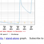
There is a great primitive campground about 1/2 way of Richland’s length where forest road 1205 crosses the creek.  Since 1974 I have hiking, photographing, or kayaking on Richland and know it very well.  By gauging Richland creek you can get a great feel for how high the smaller tighter streams are running, like Falling Water Creek, Bobtail Creek, Big Devils and Long Devils creeks.  All of these smaller creeks have individual features that make them appealing.  On the 30th of May, Richland rose up from around 150 CFS to over 9000 CFS in less than 3 hours.  This much water on Richland is easily what I would call a flash flood, and would most definitely cover the bridge at FS 1205.  This amount of water may also start to flood into the lower level of the campground. What also has to be remembered is that at the campground, Falling Water Creek also comes into Richland.  Falling Water Creek would be the largest tributary to Richland, with Bobtail creek being the 2nd.  If there was 9000 CFS at the Richland gauge, easily 1/3 of it was coming in from Falling Water Creek.   In the images below you can see just how fast Richland rose up.

[Read more…]

06/11/13 The Cut on Forest Road 1205 in Searcy and Newton Counties of Arkansas

The cut along Forest Road 1205 in Newton County, Arkansas

The cut along Forest Road 1205 in Newton County, Arkansas

Image was taken with a Sony Nex-7, Sony 16-80mm Zoom Zeiss lens @ 16mm (effective 24mm on Nex7), iso 200.  This is a composite image taken in 3 vertical segments then stitched together in Photoshop CS6 to get the final image.  Raw files were converted using Lightroom 4.1

If you have traveled the back roads of Arkansas much, you will have driven on forest road 1205.  This single road passes some of the most impressive scenery in the state.  1205 runs pretty much north and south and for about half of it’s length it parallels Falling Water Creek.  Falling Water Creek has some very impressive features including Falling Water Falls, which is a ledge drop that covers the entire width of the creek and is about 13 feet high.  1205 follows along Falling Water Creek, and then crosses over Richland creek, which is one of the best places to hike, camp and photograph in Arkansas.  From the crossing of Richland, 1205 begins a long climb up the adjoining ridges and then tops out about 1000 feet higher at Dicky Junction.  1205 can be driven in a car, but there are places where it might be a bit tough as the road has started to really fall apart here it enters Newton County.   There are many people who live along 1205 and it’s a road that is important as a U.S. mail connection.

Many people won’t remember back to March of 2008, but during this time in Arkansas there were several really heavy rains that fell in close succession to each other.  The first one of these rains started a minor slide in a weak hillside along 1205.  This spot was about 2 miles south from the Richland Creek Campground.  The slide was minor and with some bulldozer work most of it was cleared up.  In the next few weeks, more heavy rainfall caused a further weakening and eventually the entire mountainside slumped away.  The damage was tremendous and for about 1/16th of a mile where 1205 had been was only a mass jumble of downed trees and huge rocks.  Several times I attempted to hike through to the other side, but the damage was such that you really could not make much progress before coming to a huge tree or rock which required a long detour.

The plan was to have the U.S. Forest service repair the road and do a repair that would last.  In the interim, Richland Creek campground was closed and one of the most vital links for transportation was no longer there.  For about the next 2 years, not too much was done.  Many people complained about the campground being closed, but the Forest Service felt that they could not get access to this area fast enough if there was an emergency.   Traffic was routed back around the upper end of 1205 if you wanted to get to Richland.

[Read more…]

07/21/12 Richland Creek has Flatlined, a first in 18 years of hiking and boating the best creek in Arkansas

USGS graph of Richland Creek for July 16th 2012

USGS graph of Richland Creek for July 16th 2012

Arkansas has many famous spots for outdoor recreation which feature lakes, or streams.  For sure one of the best is Richland creek, in the northwest part of Arkansas.  With Richland Creek one can find a stream that is the 2nd largest tributary of the Buffalo river which has a huge watershed that cross through several Arkansas counties before emptying into the Buffalo river at Woolum.  In the winter and springtime Richland is famous for kayaking both the upper and lower portions of the creek.  During the late spring and summer Richland tends to offer a quiet and tranquil location to get away from busier parts of Arkansas.  During the autumn, Richland can offer one of the most dramatic displays of fall color in the state since there are several areas along the creek that have trees approaching 50 to 70 years of age.  I like to try and hike Richland at least 4 times during the year to catch the creek at it’s different stages each of which can offer amazing photograhic opportunities.

On my weekly checks of Richland Creek’s USGS Hydro-graph I have watched as my favorite creek has slowly dropped down the chart.  However today when I checked the creek, I was amazed to see a flat-line 0.00.  I have never in 18 years of monitoring Richland seen it this low.  The gauge is near the concrete bridge immediately below the campground and I have to assume that the large pool at the bridge is now dry or very close to being dry.  Richland’s being this low really puts into perspective just how low the state of Arkansas’s wild stream flow is currently.  I also check the Buffalo River and it is now showing 0.25 at the Boxley gauge which is also very low, even for this time of the year.

[Read more…]