From the BlogSubscribe Now

A Tale of two creeks Richland and Falling Water–02_21_19 Featured Arkansas Photography

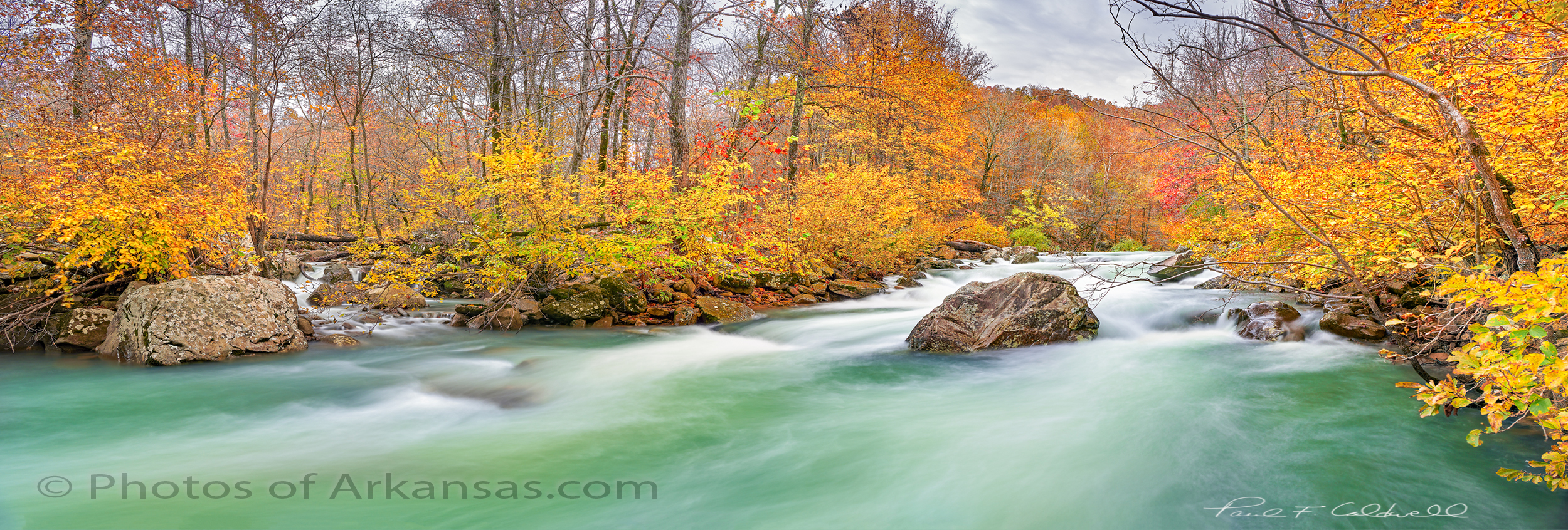
Fall scene featuring Richland and Falling Water Creek at their confluence.

A tale of two Creeks, Falling Water and Richland Creeks, Newton County Arkansas taken November 2018. 

Taken with a Nikon D850 and 24-70 lens.  Image capture in 3 horizontal images @ 24mm.  I used both a CL-PL and ND filter to slow the exposure for the water.

If I had to pick a favorite spot in Arkansas, it would have to be Richland Creek.  Most defiant a love/hate relationship as Richland alone has cost me more in camera gear than any other location I like to photograph.  Just this fall I lost both a Nikon D850 and 24-70 lens upstream from where this shot was taken.  Totally my fault and lucky for me, the creek was much lower so I was able to recover the gear and Nikon USA was able to repair it at a reasonable cost.  But that’s another story. 

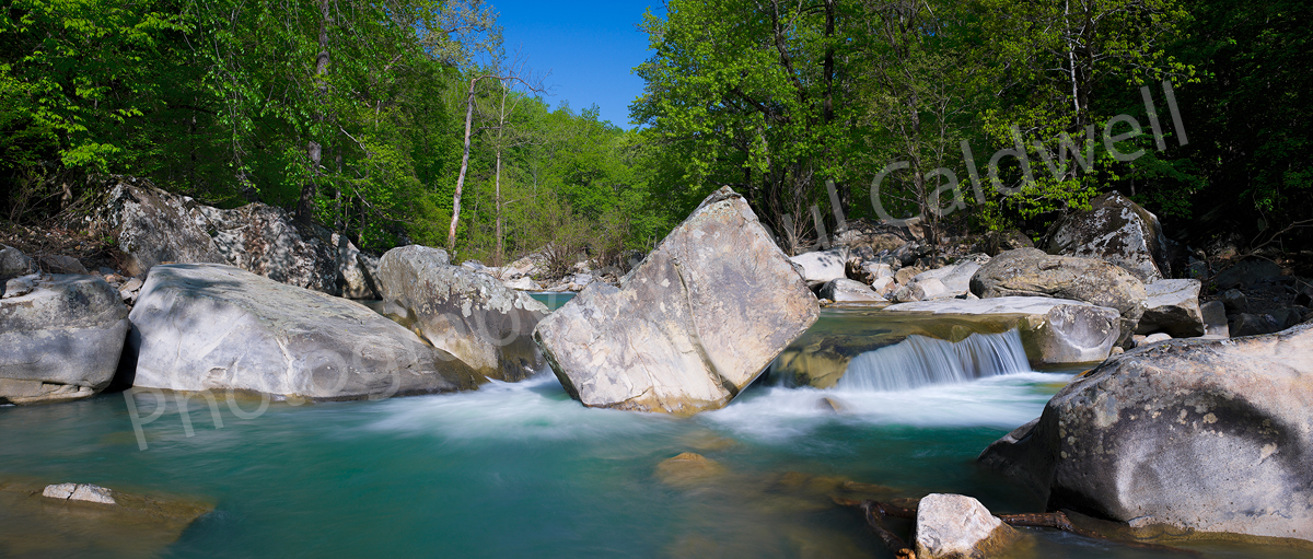
Richland Creek is one of the fascinating creeks in Arkansas.  At medium to high water levels it’s a great kayaking stream.  The creek is lined with hardwoods most are 2nd generation growth as the creek was logged back in both the great depression and again in the 60’s-70’s.  Most of the old growth trees are long gone but if you hike far enough upstream where the mules and loggers never reached you can still find some huge white oaks.

The creek also winds through some of the most remote parts of Arkansas, that are still remaining.  Most of the watershed is now a wilderness area.  There is a primitive hiking trail that works it’s way up the left side of the creek (left side facing upstream).  This trail will lead all the way to Twin Falls and Richland Falls, well worth the trip.

For most the season, Richland hold water, but in the fall it’s very rare to find a good flow like the one shown in this image.  Instead the creek is usually barely covering the rocks.  The fall colors are getting tricky to catch also.  In the past the peak display tended to be around the middle of October now the peak seems to be more in the first week of November.  But the display is now hard to catch in full.  Notice in this shot most of the larger trees on the left have dropped their leaves, but the willows and smaller hardwoods lining the creek are still in full color.  However upstream many of the larger trees are still hold leaves.  So you just have to go and see what you have.

To take this shot, I had to wade out into the creek to mid thigh deep.  I found a rock that allowed me to place my tripod and camera safely above the creek.  Still after the disaster I had just 1 week prior, I was a bit shaky on working in the creek.   Still it was just too much not to get out and risk the shot.  There was little to no wind and just as I arrived the deeply overcast sky started to breakup and gave me some nice mixed light.

Due to the high water levels, I was able to catch Falling Water Creek on the left of the shot.  Falling Water Creek runs into Richland at the Richland Campground.  Falling water breaks into several channels near the it’s mouth with Richland and this one is the smallest.  It hardly ever flows unless Richland is running at a high level.  So I was grateful to catch both creeks in the same shot with some of the most amazing fall color I have seen on the creek.


Written by Paul Caldwell for www.photosofarkansas.com.  Please contact the author before using any part of this in a separate publication. 

07/24/14 Rain and more rain brings up Arkansas’s Prime Creeks in July

Richland Creek Arkansas Ozarks

Springtime on Richland Creek in the Arkansas Ozarks

This is a view of Richland Creek in late May, taken in the 2007 time frame, but I wanted to use this photograph to show just what Richland Creek should look like now, in July!!.  Normally this time of year, the water levels in the Arkansas creeks is very low, to almost dry.  Richland will run a bit of water in the summer months, but not anywhere enough to make it worth a trip up the creek.  All that normally is available will the pools below each of the drops, like the one in this picture.

However in 2014, Arkansas has had a series of large rains, all of which hit the Ozarks.  Just 2 days ago, the Buffalo River, near Ponca was running at over 1000 CFS, which for the Buffalo in July is unheard of.  Richland was running in the 250 CFS range.

Water levels for the Buffalo River in Arkansas

USGS gauge levels for the Buffalo River in July 2014

As you can see in the graph above, the Buffalo was as high as 1000 CFS and is still in the 241 CFS range 2 days out from the rain.  This means that you could canoe the entire river from Highway 21 all the way to the mouth of the Buffalo where it runs into the White river.  But what is even more significant is look back 7 days and you can see that the Buffalo was holding in the 100 CFS range which is even more impressive.  Normally this time of year, you could expect to see around 15 CFS or less.  This is great news for the local canoe outfitters along the entire river as they can continue to rent boats into July.

Richland creek water levels in Arkansas Ozarks

Richland Creek water levels in July 2014

This graph shows the water levels for Richland Creek, which shows it did not hold to the 100 CFS range of the Buffalo but was still at 28 or so CFS before the last big rain.  Again, this is pretty impressive for a creek the size of Richland.

This means that if you like to hike the Arkansas Outdoors, July is a great time to get out.  Richland is not an easy hike in July as the undergrowth of the forest will make for a pretty hard hike.  There is no “official” trail up the creek, but if you get up there, work your way over to the left side of the creek, (when facing upstream) and you will find the age old trail that hikers have created from years of hiking up to Twin Falls or Richland Falls.  Your best bet right now is to start the hike from Richland Creek campground and after crossing Falling Water Creek, head up to the top of the adjacent ridge, where you can find the beginning of the trail that heads up Richland.


06/13/13 Review of recent highwater levels in Arkansas Ozark and Ouachita streams

Bills Thrill rapid on Richland Creek in low water

Bills Thrill rapid on Richland Creek in low water

In Arkansas, there are times of drought and times of heavy rains which create high  flows in Ozark and Ouachita mountain streams.  In a normal year, most of this high water will happen in mid to late March and most of April, and starts to wind down by mid May.  Usually by June stream flows in all but the largest trunk streams will be down to a very small flow.   However this year, all of that logic was thrown out the door as Arkansas had quite a late spring with freezing temperatures still happening into late April.  As May rolled in strong storms developed several times during the month, however by the heaviest amount of rainfall came in a period over 2 days, 05/30/13 and 06/01/13.

The heaviest amount of rain fell in the southwest part of the state, and this brought up all the main streams.  There was locally heavy flooding and some fatalities occurred during the flooding.  I tend to gauge the stream flow in Arkansas by reviewing the levels of what I determine are critical trunk streams:

  1. The Cossatot River in the southwestern corner of the state
  2. The upper end of the Buffalo National River near Ponca Arkansas
  3. Richland Creek in the center of the Richland Wilderness

I use the USGS gauges, which are online at this location.  You can get an excellent feeling for how much rain has fallen by looking at the stream flow increases.  If you look at the series of images from the gauge on the Cossatot, you can see that the stream rose to around 30,000 CFS (Cubic Feet per Second of flow) in around 2 hours.  This is classic flash flooding and is a very dangerous time to be out driving around on local road.  What’s also telling is just how fast the Cossatot fell back to a “normal” level.  By looking at the charts, you can see that really before daylight, the Cossatot had already dropped back down to a much lower level.  What is even more interesting, is that in the 2nd heavy rainfall on the night of 06/01/13, the Cossatot rose back up to close to 20,000 CFS again in less that 2 hours.

The first graph shows the two peak levels, of 30K and 20K in a total overall time frame of less than 24 hours.  The 2nd graph shows the final peak reading on 06/01/13 where the river recorded over 20K CFS. I have seen a video taken by Max Wellhouse way back in the late 1990’s of the Cossatot at 10,000 CFS, so I can only imagine it at 30,000.  The 6 falls of the Cossatot would be a site to behold if you could even get down to shoot around them.  I am assuming that the water would be pretty maxed out in the narrow canyon that is created around the 6 falls and any viewing would have to be done from above the level of the falls on the surrounding bluffs.  So what about the northwestern part of Arkansas, well not quite as much rain fell, but Richland creek most definitely saw the same double peaking like the Cossatot.

Anyone who know me or my work, knows I am a bit partial to Richland Creek.  Hands down it provides some of the best photographic studies in Arkansas.  This is true in winter, spring, summer and if you are lucky fall.   Catching Richland with a good flow in the fall is very prone to luck.  Richland is enjoyed by a huge cross section of recreation seekers in Arkansas and other local states.  This includes:

  1. Kayakers
  2. Hikers/Backpackers
  3. Photographers
  4. Hunters
  5. Fishermen

There is a great primitive campground about 1/2 way of Richland’s length where forest road 1205 crosses the creek.  Since 1974 I have hiking, photographing, or kayaking on Richland and know it very well.  By gauging Richland creek you can get a great feel for how high the smaller tighter streams are running, like Falling Water Creek, Bobtail Creek, Big Devils and Long Devils creeks.  All of these smaller creeks have individual features that make them appealing.  On the 30th of May, Richland rose up from around 150 CFS to over 9000 CFS in less than 3 hours.  This much water on Richland is easily what I would call a flash flood, and would most definitely cover the bridge at FS 1205.  This amount of water may also start to flood into the lower level of the campground. What also has to be remembered is that at the campground, Falling Water Creek also comes into Richland.  Falling Water Creek would be the largest tributary to Richland, with Bobtail creek being the 2nd.  If there was 9000 CFS at the Richland gauge, easily 1/3 of it was coming in from Falling Water Creek.   In the images below you can see just how fast Richland rose up.

[Read more…]

06/11/13 The Cut on Forest Road 1205 in Searcy and Newton Counties of Arkansas

The cut along Forest Road 1205 in Newton County, Arkansas

The cut along Forest Road 1205 in Newton County, Arkansas

Image was taken with a Sony Nex-7, Sony 16-80mm Zoom Zeiss lens @ 16mm (effective 24mm on Nex7), iso 200.  This is a composite image taken in 3 vertical segments then stitched together in Photoshop CS6 to get the final image.  Raw files were converted using Lightroom 4.1

If you have traveled the back roads of Arkansas much, you will have driven on forest road 1205.  This single road passes some of the most impressive scenery in the state.  1205 runs pretty much north and south and for about half of it’s length it parallels Falling Water Creek.  Falling Water Creek has some very impressive features including Falling Water Falls, which is a ledge drop that covers the entire width of the creek and is about 13 feet high.  1205 follows along Falling Water Creek, and then crosses over Richland creek, which is one of the best places to hike, camp and photograph in Arkansas.  From the crossing of Richland, 1205 begins a long climb up the adjoining ridges and then tops out about 1000 feet higher at Dicky Junction.  1205 can be driven in a car, but there are places where it might be a bit tough as the road has started to really fall apart here it enters Newton County.   There are many people who live along 1205 and it’s a road that is important as a U.S. mail connection.

Many people won’t remember back to March of 2008, but during this time in Arkansas there were several really heavy rains that fell in close succession to each other.  The first one of these rains started a minor slide in a weak hillside along 1205.  This spot was about 2 miles south from the Richland Creek Campground.  The slide was minor and with some bulldozer work most of it was cleared up.  In the next few weeks, more heavy rainfall caused a further weakening and eventually the entire mountainside slumped away.  The damage was tremendous and for about 1/16th of a mile where 1205 had been was only a mass jumble of downed trees and huge rocks.  Several times I attempted to hike through to the other side, but the damage was such that you really could not make much progress before coming to a huge tree or rock which required a long detour.

The plan was to have the U.S. Forest service repair the road and do a repair that would last.  In the interim, Richland Creek campground was closed and one of the most vital links for transportation was no longer there.  For about the next 2 years, not too much was done.  Many people complained about the campground being closed, but the Forest Service felt that they could not get access to this area fast enough if there was an emergency.   Traffic was routed back around the upper end of 1205 if you wanted to get to Richland.

[Read more…]

07/21/12 Richland Creek has Flatlined, a first in 18 years of hiking and boating the best creek in Arkansas

USGS graph of Richland Creek for July 16th 2012

USGS graph of Richland Creek for July 16th 2012

Arkansas has many famous spots for outdoor recreation which feature lakes, or streams.  For sure one of the best is Richland creek, in the northwest part of Arkansas.  With Richland Creek one can find a stream that is the 2nd largest tributary of the Buffalo river which has a huge watershed that cross through several Arkansas counties before emptying into the Buffalo river at Woolum.  In the winter and springtime Richland is famous for kayaking both the upper and lower portions of the creek.  During the late spring and summer Richland tends to offer a quiet and tranquil location to get away from busier parts of Arkansas.  During the autumn, Richland can offer one of the most dramatic displays of fall color in the state since there are several areas along the creek that have trees approaching 50 to 70 years of age.  I like to try and hike Richland at least 4 times during the year to catch the creek at it’s different stages each of which can offer amazing photograhic opportunities.

On my weekly checks of Richland Creek’s USGS Hydro-graph I have watched as my favorite creek has slowly dropped down the chart.  However today when I checked the creek, I was amazed to see a flat-line 0.00.  I have never in 18 years of monitoring Richland seen it this low.  The gauge is near the concrete bridge immediately below the campground and I have to assume that the large pool at the bridge is now dry or very close to being dry.  Richland’s being this low really puts into perspective just how low the state of Arkansas’s wild stream flow is currently.  I also check the Buffalo River and it is now showing 0.25 at the Boxley gauge which is also very low, even for this time of the year.

[Read more…]

07/03/12 Heat continues and burn bans abound throughout Arkansas

Yesterday, I saw the first clouds I had seen in the local sky for almost a week. In the morning, there were enough clouds to briefly darken the sky so that the local temperature was considerably cooler. The shot below was taken on a much different type of day in July about 4 years ago. When this shot was taken, Pulaski County was getting rainfall almost every other day.

Westward view from close to the summit of Pinnacle Mountain

Westward view from close to the summit of Pinnacle Mountain

Even in the shot, you can see some damage from fire however.  The amount of clouds in the sky do help a lot since they will block some the the direct light especially in the middle summer months.  For the past two days, Little Rock, has been blessed with clouds which has helped to keep our maximum temperature down below 100 degrees.

The long term forecast is showing some possible relief by the end of next week when we might be getting some more localize rainfall.

[Read more…]

07/01/12 The weather in Arkansas remains bleak–Heat and more Heat

The heat wave continues in Arkansas

The heat wave continues in Arkansas

Well as much as I would like to say “it’s all OK here in the State of Arkansas”, I really can’t.  This has to be the worst heat wave since the mid 1980’s when the state went almost 60 days with no measurable rainfall.  As you can see from the forecast page above, for the next ten days Arkansas temperatures will stay well over 95 degrees and on many days they will climb over 100 degrees.

If this continues for much longer, then you can safely assume a few things:

  1. Within 20 more days you will start to see large numbers of trees going into stress.  When this occurs the leaves will turn brown and stay on the tree until late fall.  However it also means that any hope of a good photographic fall will be ruined.
  2. Most if not all of the major trunk streams in the State are going to dry up totally, this includes the upper Buffalo River near Boxley, Piney Creek near Russellville, the Cossatot River in the Southwest corner of Arknasas, and the Mulberry River near Fort  Smith.  The smaller streams like Richland Creek have already dried up and unless the state gets some significant rainfall in July and August, I don’t think they will have anything in the fall either.
  3. The fire hazard in the state is at highest level.  On my last trip to the Buffalo River in early June, I was already seeing sights along the roads that let me know we were in for a long hot one.  The roadside wildflowers were gone and the grasses that grow along the road side were all brown.  Now almost a month later, all of these areas are going to be at a high risk if someone throws out a cigarette.
  4. Deer, Elk, and other large wildlife will stay in the deep glens and valleys of the state and not venture out in to the flats due to the excessive heat.  So wildlife photography will be much harder than stopping along the road side and taking out your camera.
  5. [Read more…]