Well, the Rump’s tariffs have finally started to hit the photography market here in the U.S. Leica had announced back in late April that they would start increases prices across the board on all U.S. camera purchases by 7%. Strange that a lot of folks either missed this or don’t believe that Rump has really implemented such strong tariffs. (There are always the folks that would rather walk off a cliff rather than wake up).
Well, Leica has done it folks. The price of a new SL3 is now 7.5K and the price of a 90-280mm lens is now 7.8K. Don’t forget that unless you are purchasing from B&H photo with their payboo card, you will also need to add more for sales tax. In Arkansas that would be an additional $50.00. So the total increase for a SL3 is now $550.00. For nothing new, just a stupid tax that Rump feels is justified and will get Leica, Panasonic, Nikon, Canon, Fuji etc. to open plants in the U.S. Really? For sure that wont’ happen.
You can also expect to see Nikon, Fuji, and Canon to start this process. Canon has already stated that their prices will increase to cover the cost of the tariffs, just not when. Nothing from Nikon. Fuji has slowed down shipping new products like the GFX100RF to the U.S.
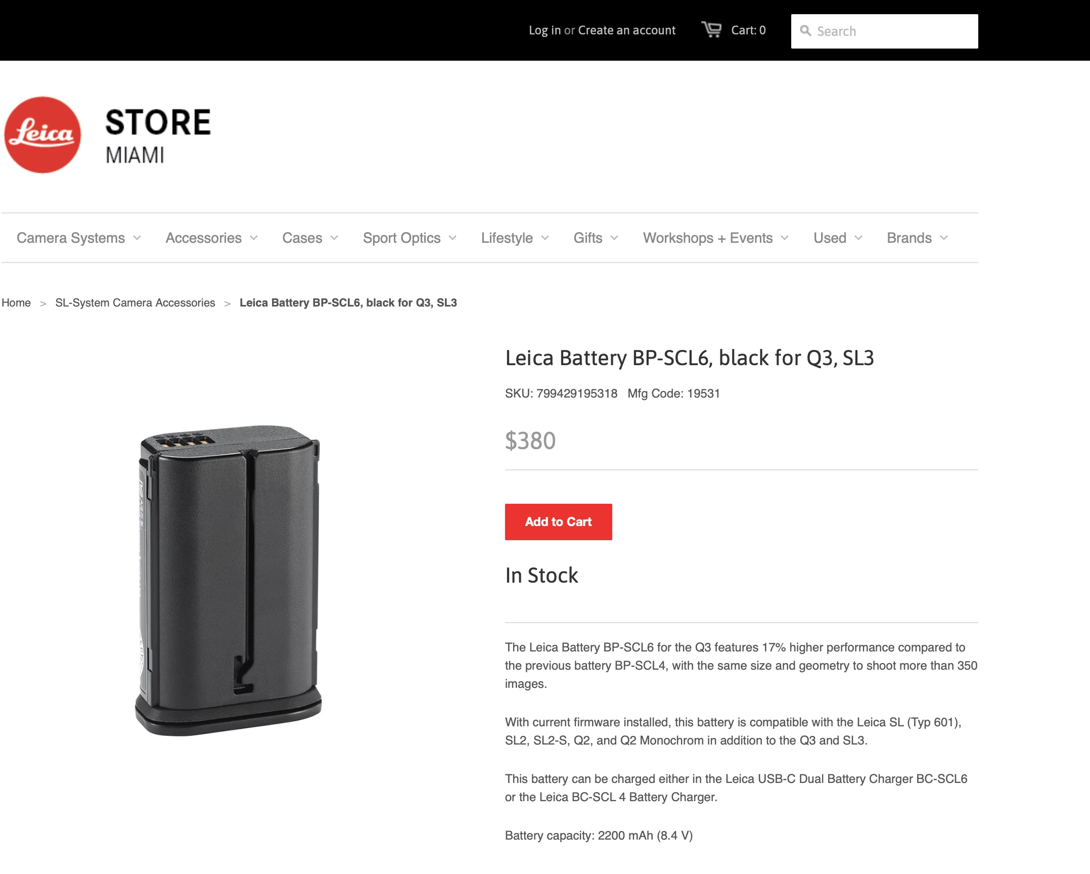
Note, the battery on the Leica SL3 is now $380.00. Basically 2x what it cost before May 1st, as Leica increased that product by 90%. I guess that battery is made in China? I can’t wait to see if DJI decides to even release the upcoming Mavic 4, as the cost will be excessive for most of the MAGA folk. Around 4.5K or as much as 6K if you purchase the full package.
Also note, don’t expect any of these prices to ever come back down, THEY NEVER DO!. Once up there, they will stay. I can also expect to see the cost of out of warranty repairs go off the scale too as most of the parts are made in China or in countries where the tariffs are over 100%.
The only company that has not responded is Hasselblad, (but note they are always behind the times just look at the Phocus software). But they are owned outright by DJI, which is a Chinese company and many of their latest products are being made in China. The 28P and 75P are examples. So they both should increase by over 100% as the current tariff on China is 145%. However the rest of the product line should have also increase by some amount as Sweden is in 10% tariff amount that has been in effect for some time.
I guess it’s a good time to start selling off some of my used equipment.


Recent Comments